St Mary’s Church Tower: Drone Survey Supporting Architectural Conservation
Aerial orbit of St Mary’s Church Tower in Hornsey, North London.
June 2025
Project Brief
This heritage survey was carried out to support the conservation of St Mary’s Tower — a Grade II* listed landmark in the heart of Hornsey. We were invited by the Friends of Hornsey Church Tower to assist their architect, Paul Jackson (RIBA, CA, AABC, IHBC), in documenting the external condition of the building.
Using a drone, we captured all elevations and the roof in a safe and methodical way. During the flight, we spotted a bit of vegetation growing in the south-west gutter and a small cavity in the brickwork on the south elevation. Fortunately, nothing urgent — but the footage helped the architect review everything remotely and confirm no immediate repairs were needed.
As well as the inspection footage, we also created high-quality visuals to support future conservation work, funding bids, and general documentation of the site.
Survey Overview:
Full coverage of all elevations and roof
Vegetation growth and minor cavity identified during the survey
Reviewed and verified on-site by the conservation architect
3D model created for structural review and public engagement
Carried out safely around a Grade II* listed building


Flight Planning
and prep
Before filming, we carried out a full pre-site assessment to make sure everything could be done safely and responsibly around the Grade II* listed tower. This included:
A risk assessment covering nearby footpaths, trees, and the historic structure itself
Confirmation of our £2 million public liability insurance
A check on local airspace restrictions
A review of weather and wind for the planned flight time
Permission and access confirmed with the landowner
The tower sits within a fairly built-up park area — mature trees, uneven ground, and tight flight paths made the job a bit more complex. We also coordinated with a nearby school (via the Friends of Hornsey Church Tower) to make sure everything went ahead safely. These factors shaped how we planned the visuals.
To stay organised, we divided each elevation and the roof into labelled grid zones. For every side of the building, we planned out vertical fly-downs and smooth horizontal tracking passes — helping us capture the finer architectural features like the battlements, stonework, and roof detail without missing anything.
This structured approach kept things safe, efficient, and consistent — ideal for conservation records and ongoing documentation.
The flight diagrams on the left show how we mapped out the key capture points and broke the tower into manageable sections for filming.

Flight planning diagrams showing labelled capture zones across all elevations and the roof of St Mary’s Tower. These guided safe, consistent image collection for conservation review.
Execution
The flight took place in June 2025. Conditions were overcast with a light breeze, which caused a bit of turbulence at times — but this was managed with manual flight adjustments to keep the footage steady throughout.
On arrival, we reviewed the flight plan on-site and made a few tweaks to account for some vegetation near the South West face. We carried out vertical and horizontal passes as planned, adjusting height and gimbal angles slightly to get the best framing.
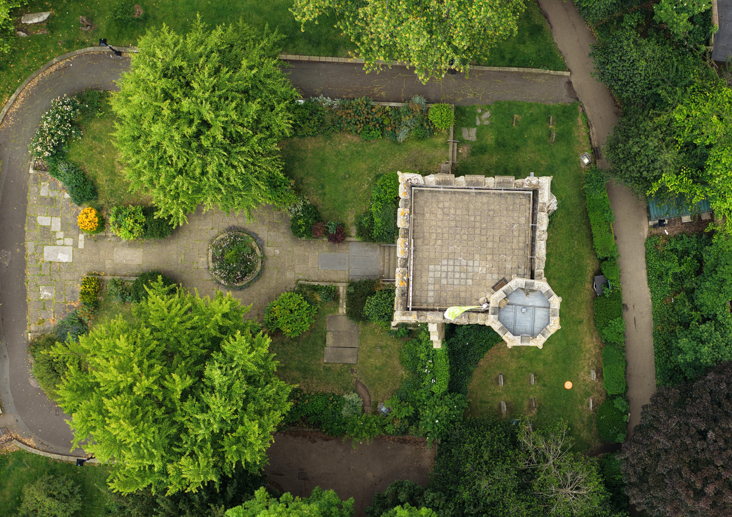
Although the tower is in a fairly tight urban park setting, we maintained safe distances from paths and trees. The drone captured detailed views of the stonework, battlements, and roof junctions across all sides.
One of the standout shots was a slow vertical fly-down of the main façade, revealing the architectural layers from the parapet right down to the base. These will be particularly useful for future conservation work and public engagement.
The flight lasted around 70 minutes in total, covering all four elevations and the roof. We started with slow vertical passes focused on the brickwork and details, followed by close roof inspections, and wrapped up with aerial orbits and top-down shots to give full context.
Some of
the findings

Shown here: vegetation buildup in the lead gutter, southwest elevation.
Gutter Vegetation – Southwest Tower Elevation
While surveying the south-west face of the tower, we spotted some vegetation growing in the lead gutter. This had already been flagged by the conservation architect, who asked us to take a closer look.
Using the drone, we captured high-resolution footage of the area — giving a clear view of both the plant growth and the gutter condition. It meant the architect could assess the situation remotely, without needing scaffolding or a tower for access.

Detail showing isolated brick loss captured via close-range drone footage.
Localised Brick Loss – South Elevation
We noticed a small patch of missing brickwork on the south side during the survey. The conservation architect asked for a closer look to check whether it showed any signs of movement or underlying damage.
The drone footage gave a clear view of the area, and after review, it was confirmed to be minor and stable. No urgent action was needed, but it’s been noted for future monitoring as part of ongoing conservation efforts.
Explore St Mary’s Church Tower in 3D
We also produced a 3D model of the tower and its immediate surroundings using drone imagery. While it’s not fully photoreal, it offers a helpful overview of the site — ideal for visual planning, access assessment, and public engagement.
Feel free to explore the model — you can zoom, rotate and pan around to get a better sense of the structure’s setting.

Final Deliverables
& Outcomes
The client was provided with a full visual package — including high-resolution photos, 4K video, a short cinematic edit, and an annotated flight plan. Everything was delivered in both web-ready and full-resolution formats to suit different needs.
These materials can now support access planning, keep an eye on vegetation, and help assess the condition of the roof — giving a clear reference point for conservation work and ongoing architectural review.
Equipment used
The survey was carried out using the DJI Mavic 4 Pro — a compact, high-performance drone fitted with a 4/3 CMOS Hasselblad camera. Its ability to shoot in 5.1K with a wide dynamic range made it ideal for picking up fine brickwork, weathered surfaces, and architectural details, even in soft, overcast light.
We chose this drone for a few key reasons:
Its lightweight design is perfect for built-up heritage sites with tight flight paths and delicate surroundings
The precision gimbal allows for smooth descents and accurate framing of vertical elevations
It runs quietly, which helps keep things discreet on-site
Footage was shot in D-Log to allow more flexibility in post-production, and delivered in both full-resolution and web-ready formats — ready for use in conservation reports, planning documents, or public engagement.
Looking to capture this level of detail for your own site?
Hire this Drone from us.

Got a Survey or Inspection Project in Mind?
Whether you’re planning a conservation survey, roof inspection, or simply need high-quality aerial imagery — we’d love to help.
We specialise in safe, heritage-sensitive drone work, delivering detailed visuals to support architectural review, restoration planning, and public engagement.
📍 Based in London — available for projects across the UK.
+44 (0) 7377 869 579
info@cavaerial.com
or drop us a message below and we will respond as soon as possible