Documenting the Tees Transporter Bridge from Above: A New Perspective on an Endangered Landmark
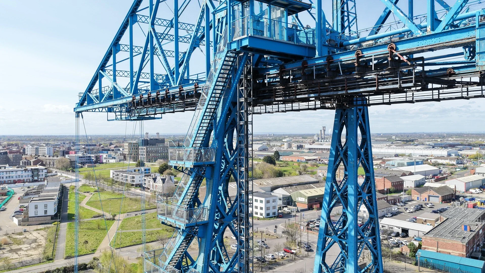
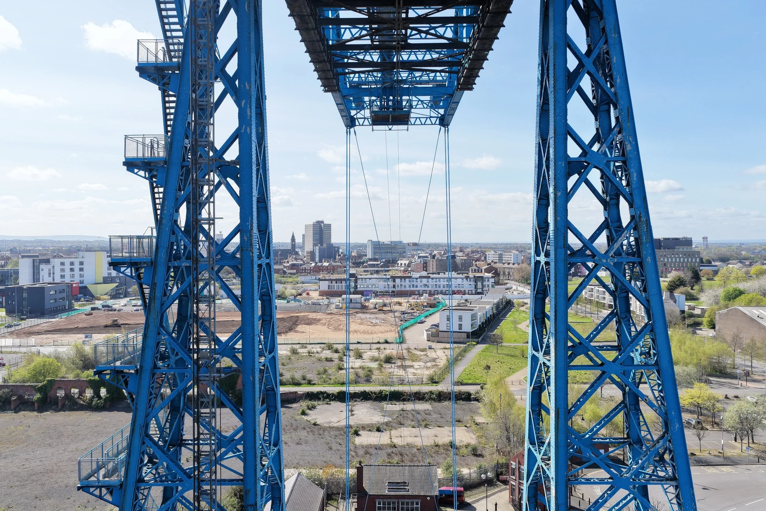
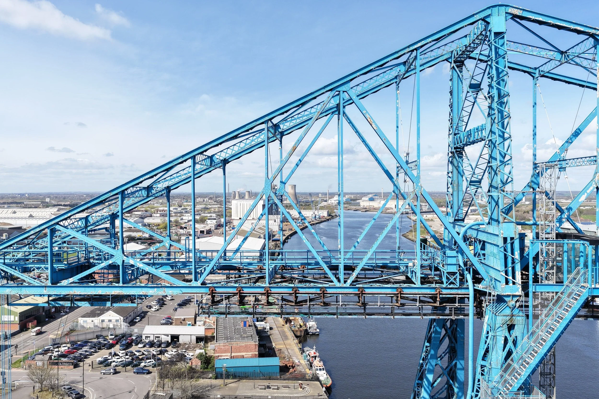
A Structure You Can’t Fully See from the Ground
The Tees Transporter Bridge is one of the most recognisable industrial structures in the UK — but it’s also one of the hardest to properly document.
From ground level, you only ever see fragments. The scale, the engineering, the condition of the upper structure — it’s largely hidden.
As part of the Victorian Society Endangered Buildings List 2026, CAV Aerial was appointed to capture the bridge in a way that simply isn’t possible using traditional methods.
Using precision drone operations, we were able to:
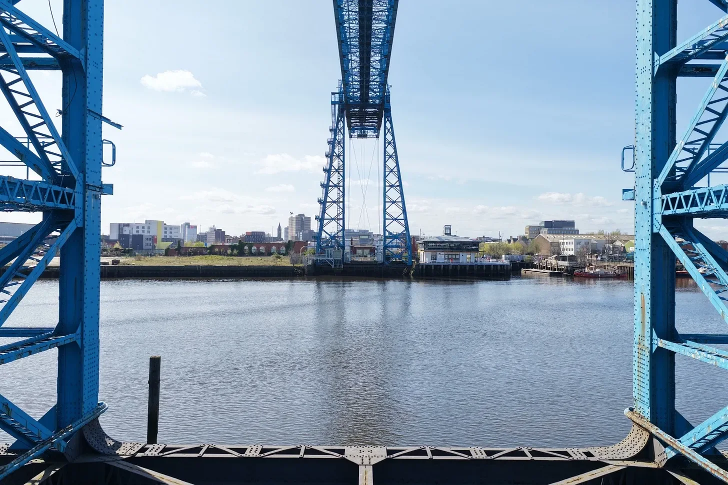
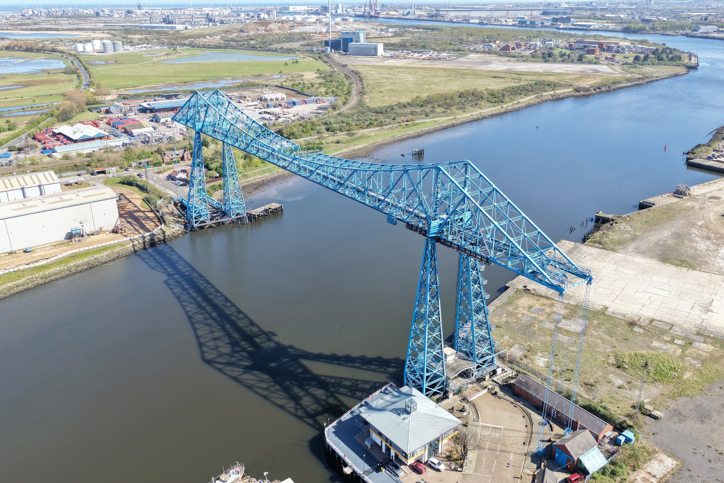
Capture the full structure from above and across the River Tees
Access elevated walkways and structural elements
Film within and around areas that are inaccessible from the ground
Produce high-resolution visual documentation for media, conservation and public awareness
This is exactly where drone technology changes things — not just better images, but access to perspectives that don’t exist otherwise.
Using precision drone operations, we were able to capture the full structure from above and across the River Tees and access elevated walkways and structural elements
A Landmark of Engineering and Identity
Opened in 1911, the bridge spans the River Tees between Middlesbrough and Port Clarence and remains the longest transporter bridge still in existence.
It was designed to solve a very specific problem:
allow ships to pass freely while still moving people and vehicles across the river via a suspended gondola.
More than just infrastructure, the bridge became:
A symbol of Teesside’s industrial heritage
A vital transport link for workers and communities
A defining feature of the North East skyline
Now One of the UK’s Most Endangered Buildings
Despite its significance, the bridge has been closed since 2019 due to structural concerns.
In 2026, it was officially added to the Top 10 Endangered Buildings list by the Victorian Society — highlighting the urgent need for investment and restoration.
Repair costs are estimated at around £60 million, placing its future in uncertainty without coordinated national support.
This is exactly why documentation matters.
Bringing the Bridge Back into Public Focus
Our work on the project formed part of a wider national campaign to raise awareness — and it gained significant media attention, including coverage by:
ITV – Middlesbrough’s transporter bridge named one of the country’s most endangered buildings
Cultured North East – Historic Tees Transporter Bridge feature
Watch the ITV coverage
Read the Cultured North East article
Through aerial documentation, the condition and scale of the structure could be communicated clearly to:
Architects
Conservation bodies
Funders
The public
This is where drones move beyond visuals — they become a tool for advocacy and preservation.
Why This Matters for the Local Community
The future of the bridge is about more than heritage.
At its peak, the bridge carried millions of crossings, connecting communities across the Tees and supporting daily life and employment.
If restored and reopened, it could:
Reconnect communities between Middlesbrough and Port Clarence
Boost local tourism and regional identity
Support regeneration and investment in the area
Preserve a globally rare piece of engineering heritage
Without intervention, there is a real risk of long-term decline — or even loss.
A New Way to Document Historic Structures
Projects like this highlight a shift in how historic buildings are recorded and understood.
Drone-based documentation allows:
Faster, safer inspections without scaffolding
Access to complex or restricted structures
Clear, high-resolution data for decision-makers
Compelling visuals for media and public engagement
For structures like the Tees Transporter Bridge, this approach is not just useful — it’s essential.
Looking Ahead
The inclusion of the bridge on the Victorian Society Endangered Buildings List is a call to action.
With the right investment, strategy, and visibility, there is a clear path to:
Restoration
Reuse
Long-term preservation
And with modern tools like drone technology, we can ensure these structures are not only saved — but properly understood.
Work With CAV Aerial
If you’re working on a historic or complex structure and need accurate, high-quality aerial documentation, get in touch.
CAV Aerial — Vision from Above