
Drone Surveys for Church Architects
High-resolution imagery, 3D models, and roof inspections formatted for quinquennial reports, grant applications, and conservation planning.
Prefer to speak to us?
✉️ info@cavaerial.com
☎️ 0203 051 6403
CAA GVC Qualified • £2m Insurance • As featured in the National Churches Trust Annual Review 2024–25 • Member of Specialist Skills Directory


Why Professionals Choose CAV Aerial
-

Rapid Turnaround
High-resolution imagery delivered in 24 hours, keeping projects on schedule.
-

Safe & Cost-Effective
No scaffolding or rooftop access needed — reducing risk and expense.
-

Trusted in Heritage
Featured in the National Churches Trust Annual Review & Specialist Skills Directory.
-

Seamless Integration
Files supplied Word/PDF-ready, formatted to drop straight into reports.
What You’ll Receive
-

Aerial Surveys for Site Assessment
✅ Get high-resolution roof and site imagery without ladders or scaffolding
✅ Reduce site time and simplify quinquennial inspections.
✅ Identify visible defects such as cracked tiles, failed flashing, damaged ridges, and guttering issues -

Survey Documentation
✅ Provide clear “before” and “after” images to support survey reports
✅ Use for warranty evidence, compliance, or dispute resolution
✅ Create a permanent visual record for planning and grant applicat -

Thermal Imaging
✅ Detect leaks, trapped moisture, insulation failure, or thermal bridging
✅Pinpoint leaks or trapped damp that threaten historic fabric
✅ Supply report-ready thermal visuals to support recommendations and funding bids -

Valley & Gutter Condition Checks
✅ Create accurate 3D models and elevations for detailed condition assessments
✅ Support structural monitoring by comparing models over time
✅ Provide interactive visuals to engage PCCs, funders, and the wider community -

3D Models & Elevation Views
✅ Create accurate 3D models and elevation views for detailed condition assessments
✅ Ideal for measuring roof areas, slopes, and complex structures without physical access
✅ Provide interactive visuals to help clients understand survey findings -
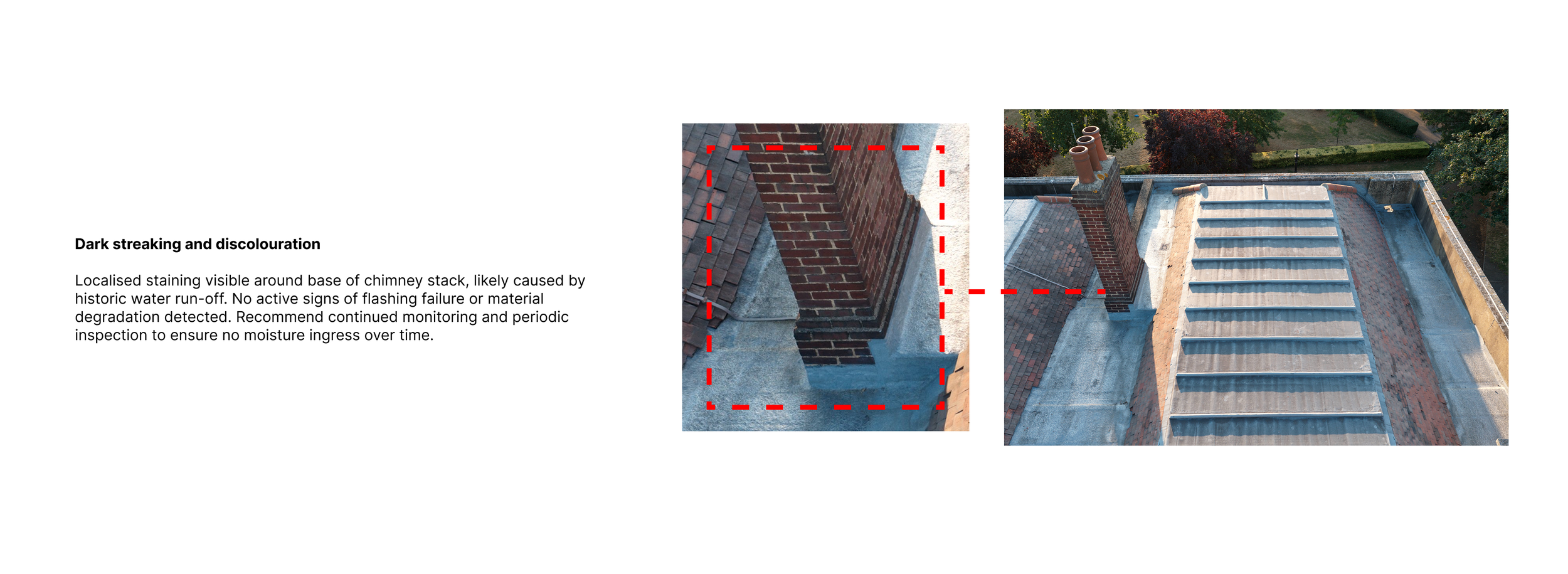
Chimney & High-Level Inspections
✅ Document masonry, pointing, and vegetation growth at height safely
✅ Provide close-up imagery for inclusion in condition and quinquennial reports
✅ Access fragile or unsafe areas without disruption to the building or site
What our clients say
Need aerial visuals for your next survey?
Send us the details and we’ll respond as soon as possible.
We work with surveyors across London and the South East and can often be on-site the same week — delivering high-resolution imagery, video, and data to support your reports.
You can also call or email us directly:
Phone: 0203 051 6403
Email: info@cavaerial.com
case study
Roof Condition Report for Haringey Council
We carried out a full roof inspection on Bruce Castle Museum and Archive. The deliverables included a 67 page report, A 3D photogrammetry model of the roof, a short promotional film and edited images for print and web.

Deliverables
-
30+ high-resolution photographs (JPEG) ready to drop into your survey reports.
-
4K video flyovers and close-ups for condition assessments and defect identification.
-
Annotated thermal scans highlighting leaks, moisture, or insulation issues.
-
All imagery and data delivered via secure download link within 24–48 hours.
From campaign films to inspections, here are just a few of the organisations we've supported.


Professional Standards & Certifications
-
![Constantine is a GVC Certified Pilot which allows him to pilot Drones up to 25 kilograms]()
GVC-qualified drone pilot authorised for commercial operations in controlled UK airspace.
-
![Design for COTRZ Academy promoting thermography specialization, featuring a circular image of a thermal camera display, logos for CPD Certification Service and UK Training Qualifications, and text emphasizing tech innovation and certification.]()
Qualified through Coptrz Academy and CPD-accredited, this certification demonstrates expertise in infrared thermography for commercial drone inspections.
-
![Heritage Trust Network logo]()
Member of the Heritage Trust Network – supporting conservation, regeneration, and promotion of historic sites across the UK.
-
![Red circular logo with the words "National Churches Trust" in white text.]()
Listed on the National Churches Trust Skills Directory, supporting churches with aerial surveys & conservation visuals
-
![Civil Aviation Authority logo with a blue background and white text]()
Registered with the UK Civil Aviation Authority (CAA) for legal and compliant drone operations.
-
![ARPAS-UK member logo – Association of Remotely Piloted Aircraft Systems, the UK’s professional drone operator network.]()
Member of ARPAS-UK, the UK’s professional association for commercial drone operators.
-
![Yellow square with black text "A2 Open Category" and a small black triangle in the top right corner.]()
A2 CofC-certified pilot approved to fly drones closer to people in low-risk environments.
-
![]()
CAV Aerial is proud to be a Gold Certified Member of the Drone Safe Register — the UK’s leading network of trusted drone operators.
-
![Logo of Coverdrone with overlapping gray circles on a blue background.]()
Fully insured with £2 million public liability cover through Coverdrone for safe, professional operations.
-
![Badge with text 'Drone Safety Verified 76 Flights,' featuring AirData UAV logo.]()
Flight logs are tracked with UAV software for full transparency and professionalism.
-
![DroneSafe Register Certified A2 CofC logo with blue check mark and circular design]()
This certification reflects our commitment to safe, competent, and legally compliant flying, recognised and verified by the UK's leading drone operator network.
-
![Drone Desk Operator]()
Using DroneDesk to plan, risk-assess, and log every flight, ensuring full compliance with UK aviation regulations.


FAQs
-
No — as long as we have access to the property and permission to take off and land, you don’t need to be there. We’ll handle everything and send you the results.
-
We can provide high-resolution JPEG images, 4K video, orthomosaic maps, and 3D models — all optimised for integration into your survey reports.
-
Most inspections start from £199 (+VAT), depending on location, size, and complexity. Send us the postcode and a brief description and we’ll quote within the hour.
-
You’ll receive a folder with:
4K images (angled, top-down, and close-ups)
Annotated observations (e.g. blocked gutters, tile movement, masonry cracks)
Optional 3D models or elevation diagrams if requested
-
Standard turnaround is within 24 hours. More complex surveys (e.g. 3D models or thermal analysis) may take 48–72 hours.
-
Yes — we hold CAA Operational Authorisation, are fully insured for £2m+, and have specific training in thermal inspections and heritage documentation. We’ve already surveyed Grade I and II* listed properties across the South East.
-
Yes — we are CAA GVC qualified and can obtain the necessary permissions to operate in most locations, including built-up areas.
-
Yes — we meet industry expectations for survey deliverables and work in partnership with chartered surveyors and architects.